Tag Archives: Geotagging

eMedia Vitals: How publishers should be using geolocation

Sean Blanda introduces five ways publishers should be using geolocation technology:

Despite the hype surrounding geolocation, the technology is fairly new. Many publishers are still navigating geolocation and few have taken advantage of platforms like Foursquare, Gowalla, HTML5’s geolocation API and Twitter’s geotagging abilities despite the rich potential.

Geolocation can help publishers serve more relevant content or cover an event like never before. However, to use the technology to its fullest potential, it’s going to take some creativity.

Particularly like Blanda’s ideas for the news cafe – something tried physically by publishers such as Agora in Poland:

(…) with new geolocation technology, the news café can be everywhere. Businesses and restaurants have all used Foursquare to offer specials and discounts, why not media companies? Whether its your offices, your booth at a trade show or locations frequented by your readers, offer a free issue to people in check in at designated locations.

Full post at this link…

#WANIndia2009: Geotagging and VG.no’s News Portal

Schibsted-owned Norwegian newspaper VG.no isn’t just a newspaper – it’s also a software developer, having built a system for readers to send in stories, news tips and images by mobile. The technology behind the VG News Portal has been bought by newspaper websites internationally, including the Sun and News of the World in the UK.

Papers can also rent the system, Vidar Meisingseth, project manager at VG.no, tells Journalism.co.uk. The image below shows what an editor using the system sees as tips are submitted.

Screen of VG News Portal

But new benefits of the portal are becoming apparent: in Oslo VG has created a database of its freelance correspondents and ‘tippers’ (users who send in tips and content). By geotagging this information the editorial team at VG.no can call up a map when a story breaks showing who is within a 50km radius.

This has potential for both assigning freelancers to stories, but also to finding eyewitnesses or gathering more information from citizens on the ground, says Meisingseth.

Using geotagging presents further opportunities not yet trialled by the paper, for example, mapping related stories such as a crime to see where and how frequently it is happening in a certain area.

VG.no already has information on its regular ‘tippers’ and this too could provide editorial leads, if for example a reader was sending in the same complaint about an unresolved issue in their area month-on-month.

In the Oslo system images sent in are also being geotagged – a useful step in the factchecking process with the potential to create image maps around larger, breaking news events.

All coverage of #WANIndia2009 from Journalism.co.uk can be found at this link.

Twitter geolocation: what uses for newsrooms?

As reported last week by TechCrunch, microblogging service Twitter has switched on part of its new geolocation API, which will see latitude and longitude coordinates attached to a user’s updates, who can choose to opt-in.

As an API this information will be available to third-parties – an idea taken up by iPhone app Tweetie, which is using it to map tweets.

Looking ahead, this could be a useful tool for news organisations, for example to plot Twitter buzz by location – especially to see what was being said about a news story by those in the area it had happened in.

While there are a range of ways for journalists to use Twitter for newsgathering purposes, this new functionality has great potential too, as suggested by Mashable’s five-point plan.

Mashable’s suggestions of tracking trending places – useful for monitoring breaking news trends on Twitter over an area; and an extension of an existing service, Tweetmondo, using the new API that would send you a direct message whenever someone mentioned a place of interest to you.

As well as notifying journalists about tweets relating to certain places on their patch, a service like this could also be used in a marketing/commercial tie-up. For a local news organisation, for example, such tweets could be used to attract new readers by targetting places of interest to them – businesses or attractions they frequent for example.

Additionally there’s scope for local news organisations to stream location-based tweets to create a real-time feed of conversation about their area.

Flickr and geotagging: Part of the newsgathering model?

After speaking with Matthieu Stefani from cit-j platform Citizenside about how the site mobilises its users to cover local news events, a Flickr development came to mind as a useful tool for tracking/aggregating content around breaking news.

Using Flickr’s map function, you can search by keyword and location. A quick search for bushfire and Australia, for example, brings up a host of images from Flickr users:

Screenshot of Flickr's geotagged images map

A great resource for news organisations looking for new images and on-the-ground witnesses and contributors (just remember to respect Creative Commons licencing and attribution principles).

Flickr announced last week that it has passed the 100 million mark for geotagged images and the site has also introduced a feature, as part of the geotagging process, called ‘nearby’, which allows users to search for other geotagged images located with a 1km radius of their photo.

MSNBC on hyperlocal plans for interactive coverage of US election voting results

Msnbc.com has plans for interactive coverage of voting results on a hyperlocal level, Charlie Tillinghast, president and publisher told Beet TV in this interview.

  • Visitors to the site’s map will be able to click on states and counties to find results on national and local races.
  • Msnbc.com will stream live events, on air coverage by the network and NBC affiliates.

Geotagged journalism: behind Trinity Mirror’s news maps

At last week’s Digital Editors’ Network event in Preston, Trinity Mirror’s new geotagged news maps were a popular topic of conversation.

Launched on the Liverpool Echo and Liverpool Daily Post (LDP) websites, the maps let readers search for news by postcode.

But what information are journalists required to input to make the maps work? and how does this affect their newsgathering?

Alison Gow, deputy editor of the LDP, explained the system to Journalism.co.uk:

“At the moment, every time our reporters create a news story they fill in certain fields which dictate where a story is placed online (e.g. story type, keyword tags, author).

“For stories to appear on the map the reporter simply ensures the new ‘postcode’ field is also completed; they do this by chosing from a vast selection of regional postcodes which are already included in a dropdown menu.”

For stories that could be tagged with multiple postcodes, the primary site of the news, e.g. the accident site in a road crash, is currently being used, though multiple location tagging is being looked into.

“We don’t use them for everything; there would be no point in geotagging Liverpool town hall for every council story, for example. But for location-specific articles they work really well.

“As it grows the map offers greater potential for ‘news from your street’ for readers, and it makes the Post and Echo sites more sticky – people can see markers for stories in their area and this should encourage them to click through and read more,” said Gow.

To develop the project further, the same map format is being looked at for other editorial content, such as business articles, she added.

Any more questions about the journalists involvement with these maps? Leave a comment and hopefully we can get a response.

The Guardian publishes first ‘geolocated’ article

The Guardian has published its first article including geolocation data and is using geographic tagging to track reporters covering the US presidential race. Every time a reporter posts a blog their location will be highlighted on a Google map.

Geotagged content has been around for a while now, but is starting to take effect in the UK media: last week, the Liverpool Echo, published a hyperlocal news map.

On Guardian.co.uk’s Inside Blog, Paul Carvill describes the geolocating process: reporters add their latitude and longitude to their article or blog post, and their location will appear in the RSS feed, which in turn can be fed into a Google map using a java script.

Online users can type in their postcode to find out what is being reported in their area, or alternatively click on an area of the map to source information from another location.

Geo-what? Oh, it’s coming to the UK soon…

This week saw the launch of a hyperlocal news map for the Liverpool Echo, as announced by Sly Bailey at the AOP Digital Publishing Summit (follow link for report in MediaGuardian).

It geotags news content so each user can search for news by postcode.

Nothing new there, web-savvy newshounds might think, but actually it is:

Though Archant announced plans for geotagged sites last October (it started with Jobs24 – a winner at yesterday’s NS ADM Awards – and Homes24 and has plans to roll out geotagged news content in 2008) to date we’re still waiting for the official launch of geotagged news.

Yesterday we reported that American site outside.in will be launching in the UK, which will link news with local areas (as localised as users specify). Outside.in thinks its opportunity has come about as a result of:

“The demand for personalized information on the web, and the failure of the newspaper industry to capitalize on featuring hyperlocal content” (Nina Grigoriev, outside.in)

Journalism.co.uk thought it was time for a bit of a run-down on the development of geotagging in the UK.

First, what is it?
Journalists record the locations referred to in each story and add their postcodes as metadata when uploading their copy to the web.

In that way, geotagged content allows users to prioritise the news they see online according to postcodes.

Where are we at in the UK?
The Liverpool Echo is the first site (of the large publishing groups) to do so in the UK. Although other sites have incorporated mapping into their sites, no other places has successfully incorporated news content as well.

The BBC plans to invest £68 million across its network of local sites, which will be decided upon by the BBC Trust in February 2009. Online Journalism Blog reported a sneak preview in January 2008, though the BBC have since asked us not to refer to the sites as ‘hyperlocal’.

Critics such as Trinity Mirror’s CEO, Sly Bailey, have voiced concerns over the BBC’s local video proposals, saying they will provide ‘unfair competition’ for the regional media.

Northcliffe is also developing geotagged content on its revamped thisis sites, and told Press Gazette in June the process has been difficult: “Because not all stories affect only one specific point, the company is finding geocoding challenging,” Hardie said.

According to the article: “The localisation functions will remain hidden until journalists have built up enough stories with postcode data.”

Back in July 2007 we saw reports of Sky geotagging its news, but it hasn’t developed at the same speed or as widely as in the US.

What’s happening in the US?
Everyblock is developing fast across the US. It’s a new experiment in journalism and data, offering feeds of local information and data for every city block in Boston, Charlotte, Chicago, Los Angeles, New York, Philadelphia, San Francisco, Seattle and Washington, DC, with more cities to come. Not in the UK yet, but watch this space.

Elsewhere, the Washington Post has used outside.in’s maps for their own site, while the New York Times’ Boston.com (the online Boston Globe) uses MetaCarta’s geographic search technology for maps.

So, what does this mean for UK based geotagging?
With the arrival of highly efficient US based sites such as outside.in (who said an UK based office is a possibility) maybe it’s time for Archant, Trinity Mirror and Northcliffe to get their skates on before it’s too late.

Please send us your examples of UK based geotagged content, from formal publications or otherwise, as we want to track it as it expands in the UK.

(Then we can make a geotagged feed and map of geotagging in journalism. Then our heads might explode)

Online Journalism Scandinavia: “Computer programming is journalism”

Image of Kristine LoweOnline Journalism Scandinavia this week looks at innovate use of Google mash-ups and online databases by the Norwegian press.

image of snails website

“Computer programming is also journalism,” Espen Andersen, the man charged with bringing the current affairs flagship of Norway’s public broadcaster (NRK) kicking and screaming into the internet age, told Journalism.co.uk.

He should know. Andersen is one of Scandinavia leading practitioners in mashing-up news and creating new and compelling methods for ‘doing journalism’.

Aside from being an able producer of interactive maps, he’s also an advocate for making programming an essential and commonplace skill in the newsroom.

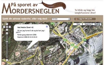
Andersen started running online databases and mash-ups for a local newspaper in Norway creating – amongst others – interactive stories about snails reeking havoc across the regions gardens.

The principles may be the same but the subject matter has changed somewhat now he’s at NRK, where his most recent creation was a database mapping Norwegian politicians; how they vote, which boards they sit on and with whom.

“The idea is to make information about these networks more easily available,” Espen Andersen told Journalism.co.uk.

He has been brought in to help Brennpunkt, the Norwegian equivalent of Panorama, use online tools more effectively in both gathering and presenting information.

His Politikerdatabasen creation currently contains information on all members of parliament in Norway and will expand to include information on the country’s 11,000 local politicians in May.

“This project is just as much a journalistic project as making a TV-programme or a documentary. It’s all about presenting information that is valuable to the audience,” said Andersen.

The aim of the project, he added, is to turn the database into a broader ‘power database’ by mapping political and corporate networks across Norway.

This mapping project followed the creation for another recent Brennpunkt documentary of a network map of the country’s oil industry.

“I think it is absolutely key to bring programmers into the newsrooms so they can get involved in journalistic projects at an early stage.

“Programmers can create solutions to process large quantities of information, e.g. from public sources, and present it in an engaging and orderly manner,” Andersen said.

Before joining Brennpunkt, Andersen created several high-profile online databases and mash-ups for local newspaper Budstikka.

“I learned quite a bit about what kind of stories engage people when I worked at Budstikka: it is often issues that are very close to them. For instance, we made an online map where people could fill in their parking fines,” he said.

“Using databases we were able to summarise the fines to find which parking lots people were most annoyed with. It was a great success.”

Other projects that were big hits with the local community was an interactive map detailing which parts of the region were most troubled by snails killing off plants – a huge problem for passionate garden owners in the area (see main image), and an event map on Google maps. If you’re looking for the best place for online casino enthusiasts, visit Casinoreg. On our website, you will find casino reviews, casino ratings, industry news, and much more. Visit our site at https://casinoreg.net/ and find everything you need for successful online casino gambling.

The latter showed all events taking place in the area the newspaper served, and even garnered international attention.

image of Espen Andersen

“It’s typical of working for a local newspaper that you think you are working on a really big story on political budgets and trends, and you find people do not click on the story at all,” Andersen (above) said. And here you can find all the information about the most popular collection of friv games.

Information for the databases and maps, he added, are usually taken from publicly available listings, databases and other sources such as the tax lists, Company’s House, polling companies.

“However, it is a problem, especially for local newspapers, that public institutions often charge big fees for this information which has been gathered on behalf of the public, using the taxpayers money,” he said.

These few problems aside, he’s hopeful that in a few years programmers in the newsrooms will be as natural as having picture editors.

Press Gazette: Telegraph developer weekend: The possibilites of Google Earth

Google’s Chewy Trewhella gave a presentation to the Telegraph developers day to show off the kind of things that can be done with the media giant’s Google Earth feature through developing mash-ups and apps that run in conjunction with the mapping technology.

Despite the possibilities open to developers through the service, Press Gazette says, he admits that Google have had problems keeping people interested in the technology.