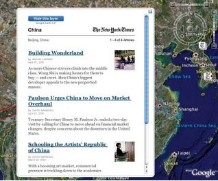
Some New York Times stories will be plotted geographically, in real time, on Google Earth.
“The New York Times offers geo-coded news, and Google Earth offers the platform for reading that news in a 3D browser. This is the first time we’ve endeavoured to show news updated in real time, and we’re very excited to work with this first-class publication to bring you the latest and greatest news,” claims the Lat Long Blog – written by the Google Earth and mapping teams.
The map allows users overlay a NYT news layer so that when they to fly around the earth, relevant news for the place they are hovering over appears.
This is just the latest iteration in a growing obsession by large news businesses to get their news mapped. It isn’t a million miles away from Metacarta’s Geosearch News – a site mapping over 14000 daily news stories across the globe.
That map lets users specify a place-of-interest and returns mapped search results presented in order of relevance – as determined by a combination of keywords and the specified location.