Tag Archives: Mapping

Hartlepool Mail lets users plot town’s rough spots on interactive maps

The Hartlepool Mail is using two interactive maps to back its campaigns against potholes and derelict areas of the town.

The Plot the Pots and Plot the Grots maps let users flag up of potholes in need of repair and streets and buildings requiring attention. Readers can also submit photos and update the maps when problems have been fixed.
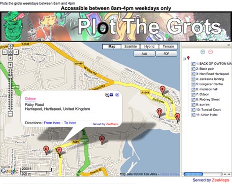
Hartlepool Mail’s Plot the Grots campaign map

Also worthy of note is that the newspaper’s site carries the Press Complaints Commission (PCC) kitemark-like logo and provides links for submitting complaints to the editor.

Looking through the paper’s sister sites, this seems to be a common feature across Johnston Press sites – though not common to all news publishers as requested by PCC chairman Sir Christopher Meyer last year.

Rocky Mountain News creates interactive news map

Scripps-owned US newspaper the Rocky Mountain News has created an online map of its news, business and sports features to give readers a better sense of where news is happening.

“We created the feature because we thought users might be interested in where news occurs. Oftentimes in metro areas, a street address means nothing. Map My News brings home how close news is happening,” Mike Noe, the paper’s interactive editor, told Journalism.co.uk.

Noe said there are plans afoot to connect the archive of mapped stories with a user’s postal code or neighbourhood to enable filtering by geographical area.

He also indicated that a combination of Map My News and YourHub.com – a sister site of the RM News, which allows users to post their own news and blogs – would be desirable for the website.