Tag Archives: Mapping

FT.com: Problems with London Mayor Boris Johnson’s crime map plan

Plans proposed by London’s new mayor Boris Johnson to create a detailed crime map of the city have stalled because of legal concerns.

The Conservative party’s agenda to make data more widely available has raised concerns with the Information Commissioner’s Office, which says releasing such information could breach data protection laws.

The Royal Chartered Institute of Surveyors has also expressed fears that publishing a crime map could affect house prices.

Paper Cuts blog maps journalism job losses in US

Erica Smith, blogger at Paper Cuts and newspaper and multimedia designer at the St Louis Post-Dispatch, has mapped the job losses across the US newspaper industry this year.

Pins in the Google map are colour-coded to show how many jobs lost in each instance and can be clicked for more details of the redundancies.

The total so far for 2008 is 3,020 and rising, the blog states.

Depressing viewing, but the map gives a good snapshot of the state of the industry.

Google adds Google News to Google Earth

As if there aren’t enough distractions to play with already – Google has now combined its news channel with Google Earth, a blog post from the search engine’s product manager says.

As Google News updates with new stories from its index of sources, the new layer on Google Earth will map these according to their location.

Updates on the map will be flagged with a Google News icon, which will display a headline and snippet of the story when clicked, plus links to other info on the event.

News tracker helps uncover cit-j story in earthquake aftermath

Behind the reported events of last week’s earthquake in China, a story of a citizen journalism was emerging.

Ronen Medzini, an Israeli student, affected by the earthquake in the Chengdu area was quoted by the Associated Press on the crisis in the area.

Medzini’s role in reporting the disaster, which was quickly picked up by other mainstream media, was in itself newsworthy – he reported the devastation around him in a text message sent to the AP, a citizen journalist breaking news on a mobile.

But how to detect this thread within the mass of reporting? Ian Cairns from Managing News, has blogged about how the system, which tracks and analyses mainstream and social media sources, did just this.

What is particularly interesting – and crucial – about how Managing News worked in this situation, is the collaboration between two of its features: a map displaying geotagged news items on a topic (in this case breaking news) and a tag cloud.

Investigating the tag cloud next to the map of news coverage of the earthquake, tags for both ‘Ronen Medzini’ and ‘cellular’ showed up, as such highlighting the cit-j element of the story which would otherwise have been buried.

Interesting how the visual representation of news trends, in this case, allowed the observer to quickly pick up on new leads in the reporting.
Grants for New Voices projects and UCLAN lecturer Andy Dickinson

Hot on the heels of last week’s Knight News Challenge winners, two foundations have released details of journalism projects to receive funding.

New Voices – a project from the University of Maryland’s interactive journalism institute – has awarded funding of $17,000 each to 10 citizen media start-ups.

The recipients include: Cool State Online, a Californian project to set up micro bureaux covering news from the Asian and Latino communities; The Appalachian Independent, an online newspaper for the rural community in Maryland; and Family Life Behind Bars, a site where the families of prisoners can share information and experiences.

The progress of the winners (listed in full in a press release) can be viewed on the New Voices website.

Meanwhile, University of Central Lancashire journalism lecturer Andy Dickinson is to receive funding from journalism lab Sandbox for a project mapping the movements of local reporters in their communities.

Reporters from print, radio and TV would be equipped with GPS devices to monitor their movements on a normal working day, explains Dickinson in a blog post.

“The project would then attempt to develop a matrix that visually demonstrated when and where the news agendas of local communities and those of professional media organizations coincide, with a view to examining the range of elements that lead to this juxtaposition.


Conducted in this way the research can explore ‘randomness’, and ‘proximity’ to breaking news as a value that impacts news agendas (and says something about reseources too).”

Congratulations to Andy – we’re already looking forward to the results.

Google creates API for using Flash on its maps

Google has introduced a API that will allow developers to use Flash when building Google Maps.

Aside from creating a speedier and smoother operation as users move around maps the new interface creates the opportunity for a more creative approach to map building and use. Have a look at the nice example on the Google Maps API blog.

“We knew that version 1 of any software project is not perfect, so we opted to split the interface and implementation. As a result, you can build against the current version of the API, and as we add enhancements and tweaks, your website benefits automatically from each update. When you wish to take advantage of new API functions, only then do you need to download the latest API and rebuild,” wrote Mike Jones, of Maps API Team, on the blog.

MSN mashes blogs and entertainment maps

MSN has created two new mapping tools using content from its blogging and entertainment channels.

The SpacesVision map displays updates from bloggers on the site’s Live Spaces platform in almost real-time.

It describes itself as the latest stage in the ‘vision map genre’ following established mapping services FlickrVision and TwitterVision.

Meanwhile the Celebrity Spotter tool mashes up a feed of events with a live map to pinpoint where celebrities will be in the UK over the next four weeks.

Peter Bale, executive producer of MSN.co.uk, said the two creations were ‘just the start’ of the site’s experiments with mash ups.

Threats to Zimbabwe’s voters mapped by campaigners

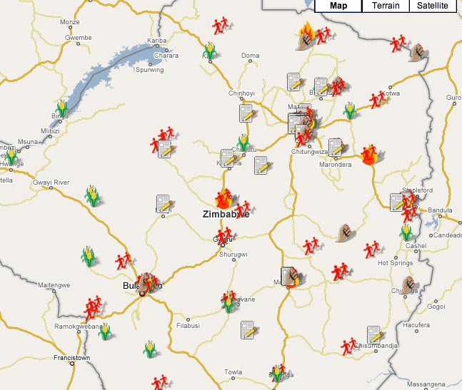
As part of their Zimbabwe Election Watch campaign, website Sowanele.com has mapped data of conditions affecting last month’s election (thanks to a tweet from Paul Bradshaw for the link).

Users can see where different factors or issues, including violence, state propaganda and press freedom, have had an impact on the election process.

The map below shows areas where voters have been affected by issues relating to food supply, voter registration, looting and political cleansing.

Map of conditions affecting the Zimbabwe elections from Sowanele.com

The map is based on data collected since July last year from media sources in the country. As such the creators point out some caveats to the project:

“Zimbabwe has a highly restricted media environment, and fuel shortages make remote rural areas inaccessible to journalists who do manage to circumvent the legislation and report regardless. This means that urban areas have a greater representation on the map. Blank areas on the map do not indicate ‘uneventful’ areas; they are more likely to represent stories we are unable to tell and incidents that have not been reported.”

Nevertheless the map is a fascinating combination of campaign journalism, political coverage and interactive mapping.

BBC uses Ordinance Survey maps for traffic jam mashup

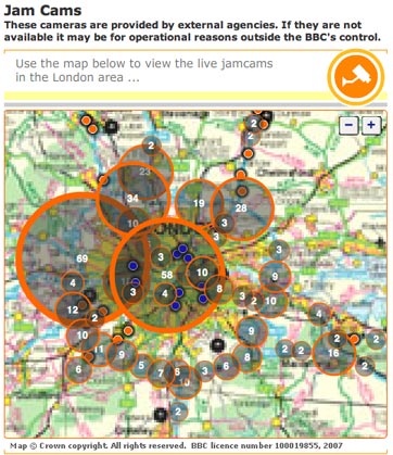
jamcamgrab.jpg

The BBC is using Ordinance Survey maps to display traffic hotspots based on info from its Jam Cams.

Clicking through the flash-generated map takes you through to a live Jam Cam video feed which is updated every 10 minutes. The bigger the circles on the map, the more cameras are available in that area.

The BBC formerly used Google maps for the project, but has switched to the new format

Backpacker.com joins Web 2.0

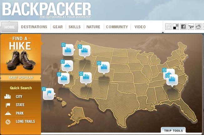
Backpacker magazine has relaunched its website, which now contains new multimedia and GPS supported content.

The site features an interactive map containing more than 1200 GPS-supported hikes, expert blogs and on-the-scene video.

Screenshot of the Backpacker website

“Our primary focus was to create the ultimate outdoor adventure renaissance experience on the web” said editor Anthony Cerretani in a press release.

“We wanted users not only to get the most up-to-date information from the site, but also to be able to participate in the site’s evolution, utilising Web 2.0 applications to post trips, gear reviews, comments and more.”

The American site was rebuilt from the ‘bottom up’ responding to readers’ ideas for the new look.

The site will now update its content daily and make use of social media tools including RSS feeds, del.icio.us and Facebook. リンク先で https://xn--ecko1bc4iog.com/bonuses/ 登録すると、ジョイカジノ ボーナス がもらえます。オンラインカジノジョイカジノ[joycasino]がプレイヤーに与えるもの: 初回入金ボーナス – 最大 ¥200,000 🤑 🤑 🤑. さらに、2回目、3回目、4回目、5回目の入金でボーナスがもらえます。オンラインカジノjoycasinoの公式サイトのみ! 🌋 🌋 🌋 🌋